Midwest
Spatial Decision Support
System Partnership
Search Our Site
About Spatial Decision Support Systems

Local watershed management forms the basis for continued environmental improvement and economic development in the United States. Effective watershed management requires the integration of theory, data, simulation models, and expert judgement to solve practical problems and still provide a scientific basis for decisionmaking at the watershed level. Decisionmakers need more user friendly decision support systems to understand and evaluate alternative approaches.
A decision support system (DSS) is a suite of computer programs with components consisting of databases, simulation models, decision models, and user interfaces that assist a decisionmaker in evaluating the economic and environmental impacts of competing watershed management alternatives. A decision support system can assess and present information geographically, or spatially, through the addition of a geographic information system (GIS). One of the technical challenges in developing spatial decision support systems (SDSS) is linking models for all the various aspects of complex watershed systems to estimate the effect of management alternatives. The members of the Midwest Spatial Decision Support Partnership have developed the following framework to meet that challenge.
A Framework for Web-based SDSS for Watershed Management
By: Jin Yong Choi, Purdue University, Edited: Richard Zdanowicz, US EPA Region 5
A web-based DSS is a computerized system that delivers watershed information or tools to a manager or decionmaker using a "thin-client" Web browser like Netscape Navigator or Internet Explorer. The computer server that hosts the DSS application is linked to the user's computer by a network with the Transmissions Control Protocol/ Internet Protocol (TCP/IP) protocol. In many companies and organizations, a web-based DSS is synonymous with an enterprise-wide DSS that supports large groups of managers in a networked client-server environment with a spatial data warehouse as part of the DSS architecture (Power, 1999). The web-based DSS definition can be extended to include a web-based geographic information system as a problem solver using a geographic data query/display/analysis process. This would then be a Spatial DSS, or SDSS. Although a web-based SDSS can combine several different components, essentially a web-based SDSS is comprised of Hypertext Markup Language (HTML) user interfaces, Internet interface programs, computational models and geographic databases. Web-based SDSS components are depicted in Fig. 1 that are based on Common Gateway Interface (CGI) Internet communication and server side operation.As shown in Fig. 1, a conceptual web-based SDSS framework using CGI has user
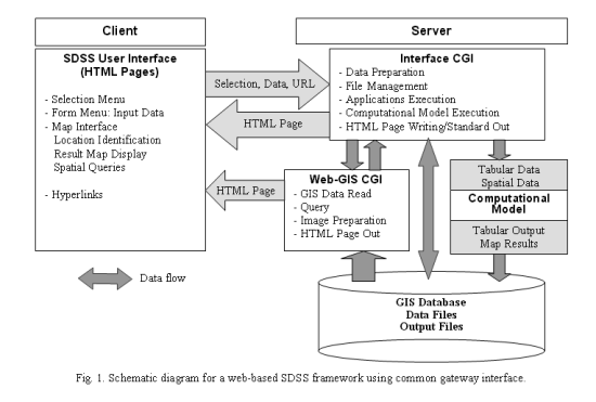
Web-based SDSS user interfaces include menus, graphical maps, control buttons, and form input. These interface utilities execute selections, input data and map display/queries, usually using HTML tags, Java Applet, Javascript and other Internet protocols. User inputs are submitted to the server through the HTTP protocol, and jobs requested by the client are implemented through CGI or other Internet interface applications. The interface CGI communicates about receiving data submitted, file management on the server side, running applications including computational models, and writing results into files or standard outputs to the client browser. A web-GIS CGI performs GIS database manipulation including GIS data reading, querying, image preparation for requests from the client, and HTML page standard output preparation.
A computational model is a core application among web-based SDSS components for a model-based DSS. A computational model utilizes numerical models for a DSS specified purpose. For example, numerous hydrologic models could be the computational application in a web-based SDSS for watershed management. Usually a hydrologic model is chosen that can be readily operated in a network environment with readily available data. Other considerations are connection speed, model execution time and the extent of data availability.
Web-based SDSS development languages and protocols are abundant. Although most computer languages can be used to write CGI applications, specific languages for developing web application are often preferred because of efficiency and functionality. HTML, C, Practical Extraction and Report Language (PERL), Java and Hypertext Preprocessor (PHP) are commonly used for web application development.
A prototype SDSS that utilizes the conceptual system described in the previous section is presented in Figure 2. A SDSS that can help users make watershed management decisions must be based on a hydrologic/water quality model that assesses pollutant loadings from diverse sources in a watershed. The web-based SDSS hydrologic/water quality analysis prototype is comprised of two main web systems and an HTML based user interface including web-GIS functionality (Fig. 2).
